
Product Center
-
Hydrological equipment monitoring station
-
Water Quality Monitor Sensor
-
Plant protection equipment
-
Food Testing Equipment
- Soil Moisture Testing Equipment Designed for High-Precision Field Soil Environmental Monitoring
- Water Level Monitoring Device Leverages Microwave Technology for All-Weather Online Hydrological Monitoring
- Practical Application of Agriculture Sensors in Soil Heat Flux Monitoring
- The remote water quality monitoring system enables real-time monitoring and intelligent control of multiple water parameters
- IoT Devices for Real-Time Monitoring of Crop Diseases and Pests Facilitate Precision Control in Smart Agriculture
- Hydrological and Rainfall Monitoring Facilities Facilitate Precise Monitoring in Hydrological Scenarios
Shandong Fengtu IOT Technology Co., Ltd
Sales Manager:Ms. Emily Wang
Tel, Whatsapp:+86 15898932201
Email:info@fengtutec.com
Add:No. 155 Optoelectronic Industry Accelerator, Gaoxin District, Weifang, Shandong, China
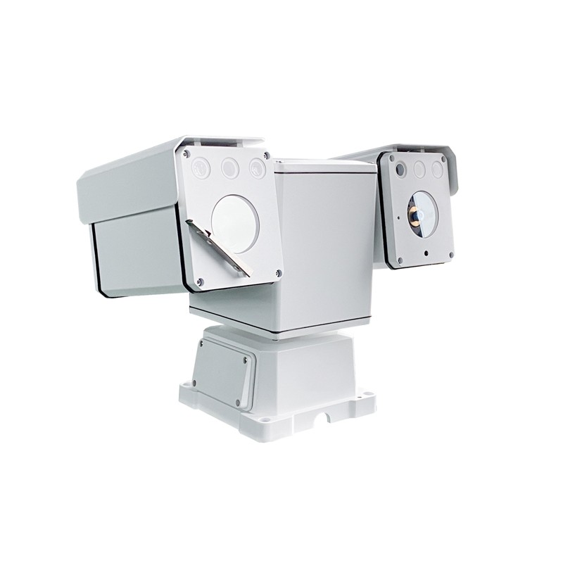
Bird Identification and Monitoring System
Model:FT-NSB16
Brand:fengtu
 Get a Free Quote
Related products
Product details
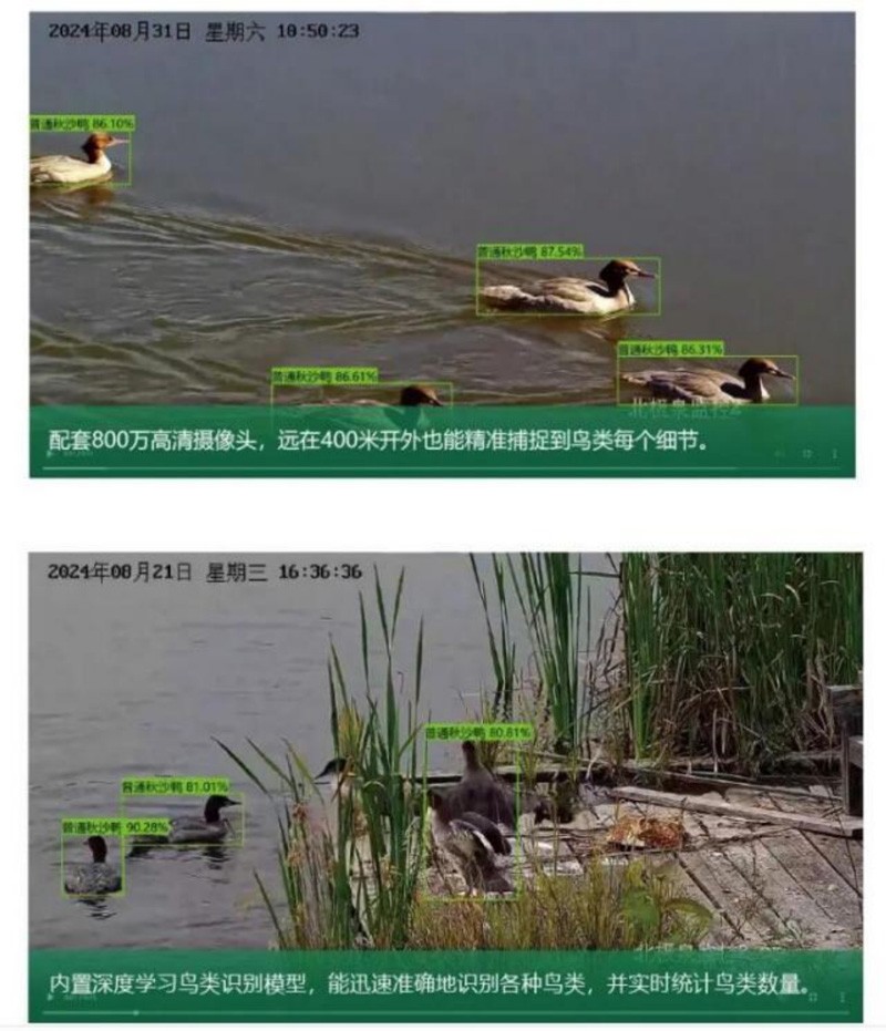
Bird Identification and Monitoring System can perform functions such as identifying specific species, counting bird numbers, and tracking bird distribution.Bird Identification and Monitoring System integrates advanced deep learning bird recognition models, multi-sensor fusion technology, and intelligent gimbal control, enabling automatic bird species identification, population statistics, distance measurement, and orientation determination, and overlaying the information onto the video stream in real time.Bird Identification and Monitoring System has greatly improved the efficiency and accuracy of ornithological research, biodiversity surveys and wildlife conservation, and provided a powerful technical tool for scientific research and practical work in related fields.
1. Introduction: Challenges and Technological Innovations in Traditional Bird Monitoring
Traditional bird field surveys primarily rely on visual observation through binoculars or manual playback and analysis of video recordings from fixed-point cameras. This method has significant limitations:
High reliance on human labor and low efficiency: Time-consuming and labor-intensive, and limited by the experience and physical strength of the surveyors.
Subjective errors exist: Species identification and population statistics are easily influenced by subjective judgment.
Limited spatiotemporal coverage: Difficult to achieve continuous, all-weather, large-scale monitoring.
Single data dimension: Usually only species and population can be recorded, making it difficult to accurately obtain spatial information such as location and distance.
The emergence of Bird Identification and Monitoring System is precisely to address these challenges. By combining cutting-edge artificial intelligence technology with sophisticated opto-mechatronics technology, it achieves automation, intelligence, digitization, and quantification of bird monitoring, marking a new era in bird monitoring technology.
2、Bird Identification and Monitoring System Core Working Principle
Bird Identification and Monitoring System is a complex integrated system whose working principle can be broken down into four core modules working collaboratively.
1. High-Definition Image Acquisition and Preprocessing Module
High-Performance Optical Lens: Employing an ultra-high-definition (e.g., 4K and above) optical zoom lens, it can capture clear details of distant birds, providing high-quality raw image data for accurate identification.
Image Signal Processing (ISP): The built-in ISP chip performs noise reduction, sharpening, wide dynamic range (WDR) adjustment, and color restoration on the raw image data, ensuring high-quality video stream output under different lighting conditions (e.g., backlighting, shadows).
2. Artificial Intelligence Bird Recognition and Analysis Engine (Core)
This is the "brain" of the entire system, and its core technology is a deep learning convolutional neural network (CNN) model.
Model Training: During the training phase, the model uses millions of labeled images containing various birds, different postures, different backgrounds, and different lighting conditions for learning. Through feature extraction via multi-layer neural networks, it learns to distinguish subtle features of different bird species, such as beak shape, feather color and pattern, body size, and flight posture.
Real-time Inference: After deployment, the system performs inference on each frame of the real-time video stream.
Object Detection: First, object detection algorithms (such as YOLO, SSD, etc.) are used to locate all objects in the video frame that could be birds, and bounding boxes are generated.
Image Classification: Then, the image region within the bounding box is cropped and input into the bird classification model to calculate the probability that the object belongs to each species, ultimately providing the most likely species label and its confidence score.
Multi-Object Tracking (MOT): To accurately count birds and avoid duplicate counting, the system uses multi-object tracking algorithms (such as SORT, DeepSORT) to assign a unique ID to each bird entering the frame and track its movement trajectory until it leaves the frame.
3. Multi-Sensor Fusion and Spatial Information Measurement Module
Simply identifying species is not enough; the system also integrates multiple sensors to acquire rich spatial information.
Laser Ranging: The camera has a built-in laser rangefinder that emits an invisible laser beam towards identified target birds. By calculating the time difference of the laser's return, the straight-line distance between the target and the camera is accurately measured.
Pan-Tilt (PTZ) Azimuth Sensor: The PTZ contains a high-precision angle sensor (such as an encoder) that provides real-time feedback on the PTZ's horizontal azimuth (Pan) and vertical tilt (Tilt) angles.
Spatial Coordinate Calculation: Combining the known camera's latitude and longitude coordinates (via the built-in GPS module or manually set), laser ranging values, and the PTZ's azimuth and tilt angles, the system can calculate the absolute geographic coordinates (latitude, longitude, and altitude) of the bird target using trigonometric geometry principles. This provides crucial data for mapping species distribution and studying bird range.
4. Intelligent Pan-Tilt and Control Module
Flexibility and Mobility: The PTZ supports continuous 360° horizontal rotation and large-angle vertical tilt, achieving truly omnidirectional, blind-spot-free monitoring.
Automatic Tracking: After target detection, the system can instruct the gimbal to automatically rotate, keeping the target centered in the frame for continuous tracking and capturing richer individual behavioral data.
Preset Positions and Cruise: Users can pre-set multiple key observation points (such as the locations of multiple bird nests), and the gimbal can automatically cruise along the set route, enabling periodic monitoring of multiple locations.
5. Data Overlay and Output Module
All analysis results (species name, quantity, distance, azimuth, geographic coordinates, timestamp, etc.) are overlaid on the video feed in real time using OSD (On-Screen Display) technology, forming a video stream with scientific data. This video and data can be transmitted in real time to a remote data center or cloud platform via wired network or 4G/5G wireless network for researchers to view in real time or for subsequent retrospective analysis.
6. Equipment Parameters
| Camera | |
| Sensor type | 1/1.8 inch high performance CMOS |
| Pixel | 800W |
| Maximum resolution | 3264x2448 |
| Focal length | 6.5mm~388mm |
| Image zoom | 40x optical zoom 16x digital zoom |
| Low light | Color: 0.001 lux @ F3.6; Black and white: 0.0001 lux @ F3.6; 0 Lux (Infrared light/laser on) |
| Focus mode | Automatic/Semi-automatic/Manual |
| Infrared fill light | Infrared auxiliary light 150 meters |
| Cloud platform | |
| Range of rotation | Horizontal range 0°~360° Vertical range: -90°~+90° |
| Key control speed | Horizontal speed: 0.1°~100°/s; speed can be set within a range of 0.1°~60°/s. |
| Automatic cruise | 8 lines, each with 32 preset points |
| Internet | |
| Network protocol | IPV4;TCP/IP;UDP;HTTP;DHCP;RTP/RTCP/RTSP;FTP;NTP;IGMP;ICMP |
| Video compression standard | H.264;H.265;MJPEG;MPEG4 |
| Interface | |
| Communication interface | 1 RJ45; 10M/100M adaptive Ethernet port; 1 RS-485 interface |
| Alarm output | SDK alarm output |
| Other | |
| Working temperature and humidity | -40℃~65℃, humidity less than 90% |
| Protection level | IP66 |
| Battery supply | DC12 |
| Power consumption | ≤30W |
| Size | 420mm(L)x210mm(W)x240mm(H) |
| Reset | ≤9kg |
This paper addresses:https://www.fengtusz.com/Bird-Detection-System/Bird-Identification-and-Monitoring-System.html
- Previous Article :no more
- Next Article:no more
Related article
-
Tubular Soil Moisture Monitor Simultaneous Measurement of Soil Moisture, Temperature, and Conductivity at Multiple Depths
2026-04-01 -
Water quality monitoring instruments Parameter Types and Application Areas Analysis
2026-01-28 -
The Power of Multi-Parameter: FT-ZS07 Multi Parameter Water Quality Monitor System
2024-10-14 -
Water quality detector
2024-08-08 -
Introduction to the Application and Functions of Buoy Water Quality Monitoring Equipment for Real-Time Hydrological and Water Quality Monitoring
2026-08-21 -
Water Level Monitoring System: Enhancing Small-Scale Reservoir Safety Through Intelligent Hydrological Monitoring
2025-08-11 -
The Critical Role of Dissolved Oxygen Sensors in Fish Farming and Water Health
2025-05-15 -
Which is the best integrated water and fertilizer system?
2024-08-22