
Product Center
-
Hydrological equipment monitoring station
-
Water Quality Monitor Sensor
-
Plant protection equipment
-
Food Testing Equipment
- The standard buoy five-parameter monitoring system enables automatic water quality data acquisition and remote transmission
- How the Tubular Soil Temperature and Moisture Monitor Achieves Simultaneous Multi-Layer Soil Parameter Measurement
- IoT Water Quality Monitoring Station enables the automatic acquisition and remote transmission of in-situ water quality monitoring data
- Soil Moisture Monitoring Enables Simultaneous Measurement of Soil Temperature and Moisture at Multiple Depths
- The high-spec buoy with five parameters enables more accurate lake water quality monitoring
- Advantages and Application Scenarios of Non-Contact Measurement Technology for Radar Water Level Monitoring Equipment
Shandong Fengtu IOT Technology Co., Ltd
Sales Manager:Ms. Emily Wang
Tel, Whatsapp:+86 15898932201
Email:info@fengtutec.com
Add:No. 155 Optoelectronic Industry Accelerator, Gaoxin District, Weifang, Shandong, China
Geological disaster monitoring
Model:FT-DZ1
Brand:fengtu
 Get a Free Quote
Related products


Product details
1.Geological disaster monitoring background
Geological disaster monitoring realize 24-hour intelligent monitoring, millimeter-level monitoring accuracy, second-level real-time warning.Geological disasters are caused by catastrophic damage to the geological environment by natural and man-made geological actions, mainly including collapse, landslides, debris flows, ground subsidence and ground fissures. my country's geological disasters are complex and diverse, with frequent disasters. It is one of the countries with the most serious geological disasters in the world. In recent years, research on landslides and debris flows has been the focus of industry research. In order to enhance the awareness of disaster prevention and reduction in the whole society, reduce casualties, maintain social stability and normal production and living order, improve people's quality of life, promote the comprehensive development of economic construction and various social undertakings in areas with serious geological disasters, and enable the people to live and work in peace and contentment, it has become an urgent task to do a good job in geological disaster warning and forecasting.
2. Overview of Geological Disaster Monitoring System
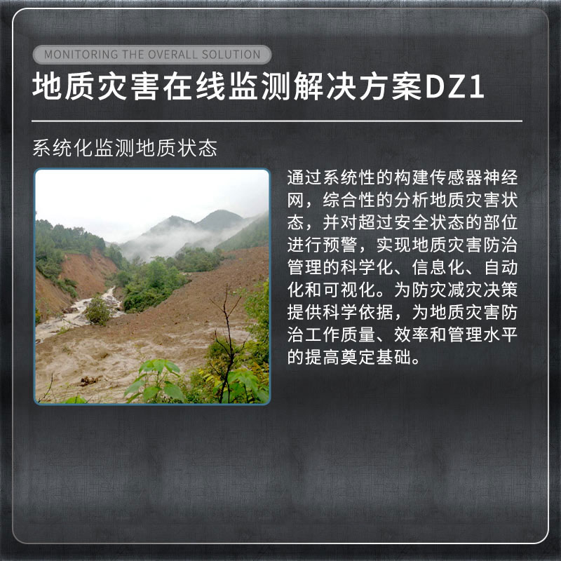
As a pioneer in industry monitoring, our company is the first to combine structural health monitoring with the Internet of Things, cloud computing and other technologies. By systematically building a sensor neural network, we comprehensively analyze the state of geological disasters and issue early warnings for parts that exceed the safe state, thus achieving scientific, information-based, automated and visualized management of geological disaster prevention and control. This provides a scientific basis for disaster prevention and mitigation decision-making and lays the foundation for improving the quality, efficiency and management level of geological disaster prevention and control work.
3. List of Geological disaster monitoring projects
| Monitoring items | Device Name |
| Surface displacement monitoring | Integrated GNSS monitoring system |
| Crack monitoring | Integrated surface displacement monitoring system |
| Deep displacement monitoring | Integrated deep displacement monitoring system |
| Groundwater level monitoring | Integrated pore water pressure monitoring system |
| Soil moisture content | Integrated soil temperature and humidity monitoring system |
| Rainfall | Integrated rainfall monitoring system |
| Video surveillance | Integrated video surveillance system |
| Mud level | Mud level monitor |
4. Geological disaster monitoring basis
Technical Specifications for Geological Hazard Monitoring DB11∕T 1677-2019
Specifications for Construction Safety Monitoring of Geological Hazard Control Projects T∕CAGHP 044-2018
《Specifications for monitoring collapse, landslide and debris flow DZ/T0221-2006》
Technical Specifications for Groundwater Environmental Monitoring HJ/T164-2004
Geological Hazard Prevention Engineering Investigation Specification DB50∕143-2003
5. Geological disaster monitoring functions
1. Through the automated monitoring platform, the management unit can realize geological information security monitoring and process management, which is no longer affected by the weather. Once an early warning occurs at any location on site, the on-site situation can be mastered through video monitoring. According to the early warning level, different alarm methods can be adopted. In conjunction with the relevant responsible units, emergency measures can be taken in a timely manner to evacuate the crowd and transfer in time to reduce the occurrence of accidents and disasters.
2. Implement a multi-level early warning and alarm mechanism from province to city to county to township, give emergency plans after early warning, and realize the integration of disaster monitoring, early warning, and response. Real-time long-term automated monitoring can prevent major landslides, mudslides and other geological disasters, reduce economic losses, and maintain social stability.
This paper addresses:https://www.fengtusz.com/Geological-Disaster-Monitor/Geological-disaster-monitoring.html
- Previous Article :Foundation pit monitoring
- Next Article:Building monitoring
Related article
-
Weather monitoring station manufacturers recommended
2024-04-12 -
From Cumbersome Laboratory Tests to Handy Portable Water Quality Monitors in Water Quality Detection
2025-02-26 -
Fengtu GNSS Monitoring Station: Building a "Smart Neural Network" for Dam Safety
2025-07-14 -
Measuring Dissolved Oxygen in Aquaculture with Water Quality Monitor FT-SC07
2025-01-09 -
Soil Moisture Monitor: Flexible Configuration, Easy Installation and Precise Data for Soil Water Dynamic Research
2025-09-09 -
Soil Monitoring Equipment Enables Rapid, Integrated, Multi-Parameter Measurement of Soil Moisture Conditions
2026-05-07 -
Vegetable base Agricultural Environment Monitoring System
2024-08-23 -
Life Detection Radar System:Penetrating Obstacles, Capturing Vital Signs, and Accelerating Life-Saving Efforts
2025-07-16